


20231212 Les Damps

Childebert
User
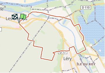

Length
9.5 km

Max alt
91 m

Uphill gradient
112 m
Km-Effort
11 km

Min alt
2 m

Downhill gradient
115 m
Boucle
Yes
Creation date :
2023-12-12 12:53:08.75
Updated on :
2023-12-12 17:24:19.946
2h30
Difficulty : Medium

FREE GPS app for hiking
 SityTrail
IGN / Geographical institutes
SityTrail Plus
The world is yours!
About
Trail Walking of 9.5 km to be discovered at Normandy, Eure, Les Damps. This trail is proposed by Childebert.
Positioning
Country:
France
Region :
Normandy
Department/Province :
Eure
Municipality :
Les Damps
Location:
Unknown
Start:(Dec)
Start:(UTM)
367274 ; 5462339 (31U) N.
Comments